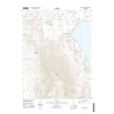
2017 Map of Saratoga Springs
USGS Topo · Published 2017About this map
The Lake Mountains dominate the western landscape of this 2017 survey, where the rapid residential expansion of Saratoga Springs and Eagle Mountain meets the natural barrier of the peaks. Along the northwestern shores of Utah Lake, the map documents a complex network of water management infrastructure, including the Provo Reservoir Canal, Gardner Canal, and Utah-Lake Distributing Canal. This irrigation system reflects the long-standing agricultural history of the Salt Lake Valley even as traditional ranching areas like Glenmar Ranch Airport are surrounded by new suburban developments. Numerous drainages such as Israel Canyon, Lott Canyon, and Mercer Canyon cut through the rugged slopes, while the Jordan River flows northward from the lake toward Lehi. The survey captures the significant transformation of the region as the corridor between the mountains and the lake becomes increasingly urbanized.
Find a feature on this map
118 named features on this map. Tap any name to fly to it.
Don’t see what you’re looking for? This feature index may not catch every label — zoom into the map to look around manually.
Map Details
Editions of this 2017 Saratoga Springs Map
This is the sole edition of this map. No revisions or reprints were ever made.
Other maps of this area

1885 · Salt Lake
USGS Topo · 1:250,000

1885 · Tooele Valley
USGS Topo · 1:250,000

1915 · Fairfield
USGS Topo · 1:62,500

1917 · Fairfield
USGS Topo · 1:62,500

1947 · Fivemile Pass
USGS Topo · 1:62,500

1947 · Goshen Pass
USGS Topo · 1:24,000

1949 · Goshen Pass
USGS Topo · 1:24,000
1950 · Soldiers Pass
USGS Topo · 1:24,000

1950 · Pelican Point
USGS Topo · 1:24,000
1950 · Lincoln Point
USGS Topo · 1:24,000