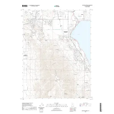
2020 Map of Saratoga Springs
USGS Topo · Published 2020About this map
Utah Lake defines the eastern edge of this northern Utah landscape, where the rapidly developing communities of Saratoga Springs and Eagle Mountain meet the rugged slopes of the Lake Mountains. The complex water management system of the region is highly visible, featuring the Provo Reservoir Canal, the Utah Lake Distributing Canal, and the Gardner Canal cutting across the valley floor. To the north, the established city of Lehi transitions into the Salt Lake Valley, connected by the Union Pacific RR and a dense network of modern parkways like Pony Express Pkwy.
Find a feature on this map
147 named features on this map. Tap any name to fly to it.
Don’t see what you’re looking for? This feature index may not catch every label — zoom into the map to look around manually.
Map Details
Editions of this 2020 Saratoga Springs Map
This is the sole edition of this map. No revisions or reprints were ever made.
Other maps of this area

1885 · Salt Lake
USGS Topo · 1:250,000

1885 · Tooele Valley
USGS Topo · 1:250,000

1915 · Fairfield
USGS Topo · 1:62,500

1917 · Fairfield
USGS Topo · 1:62,500

1947 · Fivemile Pass
USGS Topo · 1:62,500

1947 · Goshen Pass
USGS Topo · 1:24,000

1949 · Goshen Pass
USGS Topo · 1:24,000
1950 · Soldiers Pass
USGS Topo · 1:24,000

1950 · Pelican Point
USGS Topo · 1:24,000
1950 · Lincoln Point
USGS Topo · 1:24,000