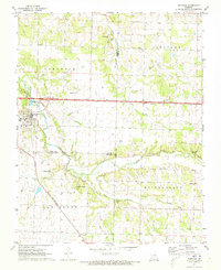
1971 Map of Sarcoxie
USGS Topo · Published 1973About this map
Sarcoxie serves as the focal point of this early 1970s survey, situated where the St Louis - San Francisco railroad tracks bisect the landscape near the junction of Jasper, Newton, and Lawrence counties. The town is characterized by its proximity to Center Creek, which winds through the central portion of the map. The surrounding countryside is dotted with springs and traditional community markers, including a dense concentration of rural houses of worship such as Bethany Ch, Independence Ch, Morningside Ch, and Downey Ch.
Find a feature on this map
31 named features on this map. Tap any name to fly to it.
Don’t see what you’re looking for? This feature index may not catch every label — zoom into the map to look around manually.
Map Details
Editions of this 1971 Sarcoxie Map
This is the sole edition of this map. No revisions or reprints were ever made.
Other maps of this area

1886 · Greenfield
USGS Topo · 1:125,000

1886 · Carthage
USGS Topo · 1:125,000

1888 · Greenfield
USGS Topo · 1:125,000

1894 · Carthage
USGS Topo · 1:125,000

1921 · Stotts City
USGS Topo · 1:62,500

1921 · Sarcoxie
USGS Topo · 1:62,500

1943 · Ritchey
USGS Topo · 1:62,500

1943 · Monett
USGS Topo · 1:62,500

1945 · Harrison
USGS Topo · 1:250,000

1947 · Joplin
USGS Topo · 1:250,000