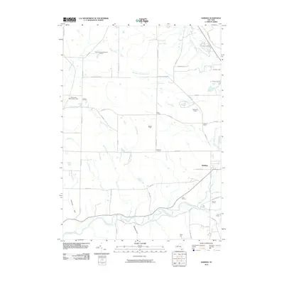
2010 Map of Sardinia
USGS Topo · Published 2010About this map
The southern border of Erie County is defined here by the winding course of Cattaraugus Creek, where the local landscape transitions from the agricultural flats of Sardinia into the more varied terrain of the southern tier. The settlement pattern is anchored by a network of historic crossroads, including Scott Corners, Shepards Corners, and Sillimans Corners, which reflect the early transit routes of the township. Local history is preserved in sites such as Pratham Cemetery and Smith Cemetery, while the area's modern character is shaped by recreational land use, including several youth retreats like Camp Ti-Wa-Ya-Ee and Camp Seven Hills. Aviation history is also represented through Gentzke Aeronautical Park Airport and High Acres Airport. The presence of the Erie County Reforestation Area in the northwest quadrant indicates long-standing land conservation efforts that contrast with the active creek-side developments at The Forks.
Find a feature on this map
57 named features on this map. Tap any name to fly to it.
Don’t see what you’re looking for? This feature index may not catch every label — zoom into the map to look around manually.
Map Details
Editions of this 2010 Sardinia Map
This is the sole edition of this map. No revisions or reprints were ever made.
Other maps of this area

1923 · Arcade
USGS Topo · 1:62,500

1924 · Ellicottville
USGS Topo · 1:62,500

1924 · Franklinville
USGS Topo · 1:62,500

1925 · Springville
USGS Topo · 1:62,500

1925 · Arcade
USGS Topo · 1:62,500

1941 · Ellicottville
USGS Topo · 1:62,500

1942 · Franklinville
USGS Topo · 1:62,500
1954 · Springville
USGS Topo · 1:24,000
1955 · Holland
USGS Topo · 1:24,000
1955 · Colden
USGS Topo · 1:24,000