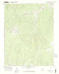
1967 Map of Sargents Mesa
USGS Topo · Published 1969About this map
The Continental Divide snakes through this high-altitude landscape in the late 1960s, marking the hydrological boundary between the Gunnison National Forest and Rio Grande National Forest. A primary point of human activity in this wilderness is the Long Branch Guard Station, situated near the confluence of the Long Branch and Wild Dog Creek. The map documents a complex network of transportation routes suited for the terrain, including an Old RR Grade in the northeast corner and various Jeep Trails and Pack Trails crossing the Cochetopa Hills. Notable peaks and plateaus like Long Branch Baldy and Sargents Mesa overlook numerous drainage systems such as Rio Grande Creek and East Sheep Creek, illustrating the remote character of this mountain region.
Find a feature on this map
35 named features on this map. Tap any name to fly to it.
Don’t see what you’re looking for? This feature index may not catch every label — zoom into the map to look around manually.
Map Details
Editions of this 1967 Sargents Mesa Map
3 editions found
Other maps of this area

1956 · Montrose
USGS Topo · 1:250,000

1959 · Montrose
USGS Topo · 1:250,000

1960 · Montrose
USGS Topo · 1:250,000

1962 · Doyleville
USGS Topo · 1:24,000

1962 · West Baldy
USGS Topo · 1:24,000

1964 · Sargents
USGS Topo · 1:24,000
1967 · North Pass
USGS Topo · 1:24,000

1967 · Sargents Mesa
USGS Topo · 1:24,000

1967 · Trickle Mountain
USGS Topo · 1:24,000

1967 · Lake Mountain NE
USGS Topo · 1:24,000