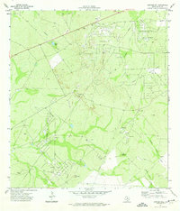
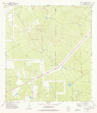
1971 Map of Sarnosa Hill
USGS Topo · Published 1974About this map
The Government Wells Oil Field and surrounding energy landscapes dominate this South Texas terrain during the early 1970s. The region is defined by a dense network of extraction infrastructure, where extensive pipelines and access roads connect various producing zones including the Lundell Oil Field and the Sarnosa Oil Field. Amidst these industrial operations, the map shows the scattered ranching and logistical footprint of the era, marked by the Daval Ranch and a remote Landing Strip.
Find a feature on this map
21 named features on this map. Tap any name to fly to it.
Don’t see what you’re looking for? This feature index may not catch every label — zoom into the map to look around manually.
Map Details
Editions of this 1971 Sarnosa Hill Map
This is the sole edition of this map. No revisions or reprints were ever made.
Other maps of this area

1956 · Freer
USGS Topo · 1:62,500

1956 · Las Mujeres
USGS Topo · 1:62,500

1956 · Laredo
USGS Topo · 1:250,000

1968 · Mills Bennett
USGS Topo · 1:24,000

1968 · Parrilla Creek NW
USGS Topo · 1:24,000

1968 · Parrilla Creek NE
USGS Topo · 1:24,000
1971 · Freer North
USGS Topo · 1:24,000
1971 · Freer South
USGS Topo · 1:24,000
1971 · Freer NW
USGS Topo · 1:24,000
1974 · Biel Lake SE
USGS Topo · 1:24,000