
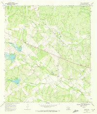
1968 Map of Parrilla Creek NE
USGS Topo · Published 1971About this map
Pipelines and an expansive Oil Field define the industrial landscape of this South Texas region during the late 1960s. The terrain is deeply etched by a network of seasonal drainages, most notably Las Animas Creek and its various branches, including North Animas Creek and South Animas Creek. In the southwest corner, the namesake Parrilla Creek divides into North Parrilla Creek and South Parrilla Creek, illustrating the complex watershed of the Duval County brush country. While much of the land is dedicated to petroleum extraction, evidenced by numerous Oil Wells and a Gas Well, the San Isidro Cem in the southeast serves as a quiet marker of the area's rural heritage. This survey captures a moment when the regional economy was heavily driven by the subterranean resources found beneath these arid creek beds.
Find a feature on this map
16 named features on this map. Tap any name to fly to it.
Don’t see what you’re looking for? This feature index may not catch every label — zoom into the map to look around manually.
Map Details
Editions of this 1968 Parrilla Creek NE Map
This is the sole edition of this map. No revisions or reprints were ever made.
Other maps of this area

1956 · Benavides
USGS Topo · 1:62,500

1956 · Rosita Ranch
USGS Topo · 1:62,500

1956 · Freer
USGS Topo · 1:62,500

1956 · Laredo
USGS Topo · 1:250,000

1967 · Parrilla Creek SE
USGS Topo · 1:24,000

1968 · Parrilla Creek SW
USGS Topo · 1:24,000

1968 · Benavides NW
USGS Topo · 1:24,000

1968 · Benavides
USGS Topo · 1:24,000

1968 · Parrilla Creek NW
USGS Topo · 1:24,000
1968 · Rosita
USGS Topo · 1:24,000