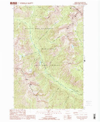
1988 Map of Saska Peak
USGS Topo · Published 1988About this map
Entiat Mountains and the Chelan Mountains dominate this high-elevation corridor within the Wenatchee National Forest. The landscape is defined by the headwaters of the Entiat River, which is fed by numerous alpine tributaries such as Snow Creek and Anthem Creek. The survey identifies the Glacier Peak Wilderness boundary, marking a transition into more protected alpine environments. Significant summits like Saska Peak and Emerald Peak tower over the drainage basins, while lower-elevation landmarks such as the Cottonwood Guard Station and Cottonwood Campground provide points of human interface with the backcountry. Notable high-altitude passes, including Borealis Pass and Saska Pass, indicate established routes through the steep terrain, connecting isolated basins like the one containing Myrtle Lake.
Find a feature on this map
40 named features on this map. Tap any name to fly to it.
Don’t see what you’re looking for? This feature index may not catch every label — zoom into the map to look around manually.
Map Details
Editions of this 1988 Saska Peak Map
2 editions found
Other maps of this area

1901 · Chiwaukum
USGS Topo · 1:125,000

1902 · Stehekin
USGS Topo · 1:125,000

1904 · Stehekin
USGS Topo · 1:125,000

1904 · Chiwaukum
USGS Topo · 1:125,000

1944 · Holden
USGS Topo · 1:62,500

1944 · Lucerne
USGS Topo · 1:62,500

1949 · Lucerne
USGS Topo · 1:62,500

1949 · Holden
USGS Topo · 1:62,500

1955 · Concrete
USGS Topo · 1:250,000

1957 · Wenatchee
USGS Topo · 1:250,000