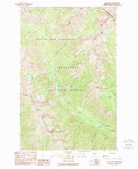
1988 Map of Saska Peak
USGS Topo · Published 1988About this map
The Entiat Mountains and the Chelan Mountains converge in this high-elevation region of the Wenatchee National Forest, where the Entiat River carves a deep central drainage. In the late 1980s, this landscape was defined by its protected status within the Glacier Peak Wilderness, showing a terrain dominated by significant peaks like Saska Peak and Emerald Peak. Human presence is concentrated along the river corridor, marked by the Cottonwood Guard Station and the nearby Cottonwood Campground. Numerous high-country water features, including Choral Lake, Fern Lake, and Myrtle Lake, sit tucked into the basins between ridges like Duncan Ridge. The map documents a network of alpine passes, such as Milham Pass and Borealis Pass, that have long served as the primary routes through this formidable section of the Cascades.
Find a feature on this map
39 named features on this map. Tap any name to fly to it.
Don’t see what you’re looking for? This feature index may not catch every label — zoom into the map to look around manually.
Map Details
Editions of this 1988 Saska Peak Map
2 editions found
Other maps of this area

1901 · Chiwaukum
USGS Topo · 1:125,000

1902 · Stehekin
USGS Topo · 1:125,000

1904 · Stehekin
USGS Topo · 1:125,000

1904 · Chiwaukum
USGS Topo · 1:125,000

1944 · Holden
USGS Topo · 1:62,500

1944 · Lucerne
USGS Topo · 1:62,500

1949 · Lucerne
USGS Topo · 1:62,500

1949 · Holden
USGS Topo · 1:62,500

1955 · Concrete
USGS Topo · 1:250,000

1957 · Wenatchee
USGS Topo · 1:250,000