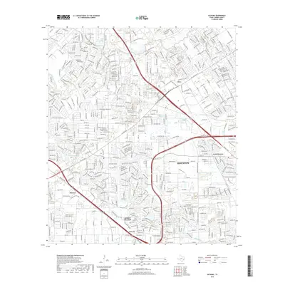
2019 Map of Satsuma
USGS Topo · Published 2019About this map
Jersey Village sits at the heart of this suburban expansion northwest of Houston, where residential subdivisions have transformed the landscape along the Whiteoak Bayou corridor. The map reveals the dense residential networking of the late 2010s, yet preserves the names of older, distinct communities like Satsuma, Melendy, and Deco. Significant water features like Cypress Creek and its associated Pillot Gully define the local topography, while historic sites such as Perry Cem and Dowdell Cem offer clues for genealogists tracking early family settlements in the region. The thoroughfares of Hempstead HWY and Tomball Pkwy anchor the transportation network, illustrating how modern transit corridors replaced the older rural paths through this part of Harris County. This level of detail captures a specific moment of transition where established neighborhoods meet the persistent water systems of the Texas Gulf Coast.
Find a feature on this map
21 named features on this map. Tap any name to fly to it.
Don’t see what you’re looking for? This feature index may not catch every label — zoom into the map to look around manually.
Map Details
Editions of this 2019 Satsuma Map
This is the sole edition of this map. No revisions or reprints were ever made.
Other maps of this area

1915 · Houston Heights
USGS Topo · 1:24,000

1915 · Cypress
USGS Topo · 1:24,000

1915 · Addicks
USGS Topo · 1:24,000

1915 · Hillendahl
USGS Topo · 1:24,000

1916 · Rose Hill
USGS Topo · 1:24,000

1916 · Aldine
USGS Topo · 1:24,000

1916 · Louetta
USGS Topo · 1:24,000

1916 · Satsuma
USGS Topo · 1:24,000

1916 · Spring
USGS Topo · 1:24,000

1918 · Cypress
USGS Topo · 1:31,680