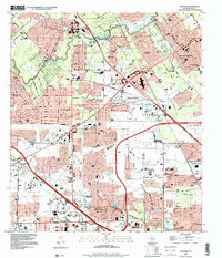
1995 Map of Satsuma
USGS Topo · Published 2000About this map
The suburban development of northwest Harris County is well-established in the mid-1990s, defined by the expansion of Houston Corporate Boundary into previously rural landscapes. Large residential enclaves like Champions, Prestonwood Forest, and Greenwood Forest are shown alongside the incorporated city of Jersey Village, which centers around Jersey Lake. The landscape is increasingly managed by drainage infrastructure, including the systems surrounding Greens Bayou and Whiteoak Bayou, yet still retains pockets of older local history represented by the Perry Cem and the Satsuma community.
Find a feature on this map
53 named features on this map. Tap any name to fly to it.
Don’t see what you’re looking for? This feature index may not catch every label — zoom into the map to look around manually.
Map Details
Editions of this 1995 Satsuma Map
This is the sole edition of this map. No revisions or reprints were ever made.
Other maps of this area

1915 · Houston Heights
USGS Topo · 1:24,000

1915 · Cypress
USGS Topo · 1:24,000

1915 · Addicks
USGS Topo · 1:24,000

1915 · Hillendahl
USGS Topo · 1:24,000

1916 · Rose Hill
USGS Topo · 1:24,000

1916 · Aldine
USGS Topo · 1:24,000

1916 · Louetta
USGS Topo · 1:24,000

1916 · Satsuma
USGS Topo · 1:24,000

1916 · Spring
USGS Topo · 1:24,000

1918 · Cypress
USGS Topo · 1:31,680