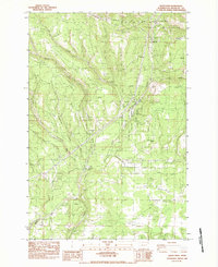
1983 Map of Satus Pass
USGS Topo · Published 1983About this map
Simcoe Mountains terrain dominates this 1983 provisional survey of the high country along the border of the Yakima Indian Reservation. The landscape is defined by the steep descent from Bickleton Ridge and the complex drainage system feeding the Little Klickitat River, including its Prong and East Prong branches. Human presence is centered on the corridor near Satus Pass, where Brooks Memorial State Park provides a preserved island of recreation amidst the timber and grazing lands.
Find a feature on this map
18 named features on this map. Tap any name to fly to it.
Don’t see what you’re looking for? This feature index may not catch every label — zoom into the map to look around manually.
Map Details
Editions of this 1983 Satus Pass Map
This is the sole edition of this map. No revisions or reprints were ever made.
Other maps of this area

1937 · White Swan
USGS Topo · 1:125,000

1950 · Yakima
USGS Topo · 1:250,000

1953 · The Dalles
USGS Topo · 1:250,000

1956 · The Dalles
USGS Topo · 1:250,000

1957 · The Dalles
USGS Topo · 1:250,000

1957 · Goldendale
USGS Topo · 1:62,500

1957 · Satus Pass
USGS Topo · 1:62,500

1958 · Yakima
USGS Topo · 1:250,000

1961 · Yakima
USGS Topo · 1:250,000
1965 · Kusshi Creek
USGS Topo · 1:24,000