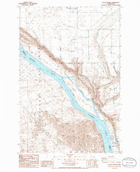
1986 Map of Savage Island
USGS Topo · Published 1986About this map
The Columbia River serves as a stark boundary between the nuclear-industrial legacy and environmental preservation of eastern Washington. On the western shore lies a portion of the Hanford Site (DOE), a Department of Energy reservation established during the mid-20th century. This restricted territory contrasts sharply with the Wahluke Slope Habitat Management Area to the east, where the landscape is defined by its ecological use rather than industrial production. Centered in the river channel, Savage Island remains a prominent feature within this transition zone. Infrastructure supporting the region’s agricultural and industrial needs is evident through several Storage Bins and water management features like the Siphon and Wasteway. The presence of a Borrow Pit and Gravel Pit along the bluffs further indicates the localized excavation required to maintain the roads and facilities servicing this unique landscape.
Find a feature on this map
16 named features on this map. Tap any name to fly to it.
Don’t see what you’re looking for? This feature index may not catch every label — zoom into the map to look around manually.
Map Details
Editions of this 1986 Savage Island Map
This is the sole edition of this map. No revisions or reprints were ever made.
Other maps of this area

1917 · Pasco
USGS Topo · 1:125,000

1924 · Hanford
USGS Topo · 1:62,500

1925 · Scooteney Lake
USGS Topo · 1:62,500

1951 · Scooteney Lake
USGS Topo · 1:62,500

1951 · Richland
USGS Topo · 1:62,500

1951 · Hanford
USGS Topo · 1:62,500

1953 · Walla Walla
USGS Topo · 1:250,000

1958 · Walla Walla
USGS Topo · 1:250,000

1965 · Mesa
USGS Topo · 1:62,500

1965 · Eltopia
USGS Topo · 1:62,500