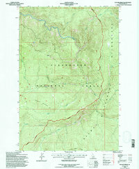
1994 Map of Savage Ridge
USGS Topo · Published 1997About this map
Colt Killed Creek snakes through the center of this mountain landscape, marking a significant drainage divide within the Clearwater National Forest. The geography is defined by high, narrow divides such as Savage Ridge and Hidden Creek Ridge, which separate the myriad small tributaries like Storm Creek and Crab Creek feeding the larger waterway. This 1994 revision reflects the protected status of the eastern and southern portions of the sheet, which fall within the Selway-Bitterroot Wilderness. This wilderness boundary creates a stark transition in land management, where established trails and forest roads give way to undeveloped backcountry. Prominent peaks including Tamarack Mountain provide clear vantage points over the complex network of creeks, such as Rabbit Creek and Savage Creek, that define the Idaho interior before the era of modern road expansion.
Find a feature on this map
22 named features on this map. Tap any name to fly to it.
Don’t see what you’re looking for? This feature index may not catch every label — zoom into the map to look around manually.
Map Details
Editions of this 1994 Savage Ridge Map
This is the sole edition of this map. No revisions or reprints were ever made.
Other maps of this area

1901 · Hamilton
USGS Topo · 1:125,000

1911 · Lolo
USGS Topo · 1:250,000

1912 · Missoula
USGS Topo · 1:125,000

1913 · Lolo
USGS Topo · 1:250,000

1956 · Hamilton
USGS Topo · 1:250,000

1959 · Hamilton
USGS Topo · 1:250,000

1960 · Hamilton
USGS Topo · 1:250,000

1964 · Hamilton
USGS Topo · 1:250,000

1964 · Rocky Point
USGS Topo · 1:24,000

1964 · Roundtop
USGS Topo · 1:24,000