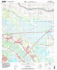
1998 Map of Savoie
USGS Topo · Published 2000About this map
Bayou Lafourche and its complex network of drainage canals and distributaries define this region of the south Louisiana coastal plain. This 1990s record of the landscape reveals a transition between concentrated residential settlement and the industrial infrastructure of the Lafourche Crossing Oil and Gas Field. The community of Savoie and the neighborhood of Broadmoor are established along the bayous, where human habitation is historically tethered to the natural levees and high ground. Several religious and educational landmarks, including St Mary Sch and the Immaculate Heart of Mary Ch, anchor the local communities.
Find a feature on this map
34 named features on this map. Tap any name to fly to it.
Don’t see what you’re looking for? This feature index may not catch every label — zoom into the map to look around manually.
Map Details
Editions of this 1998 Savoie Map
This is the sole edition of this map. No revisions or reprints were ever made.
Other maps of this area

1892 · Lac Des Allemands
USGS Topo · 1:62,500

1892 · Gibson
USGS Topo · 1:62,500

1892 · Houma
USGS Topo · 1:62,500

1892 · Thibodaux
USGS Topo · 1:62,500

1897 · Gibson
USGS Topo · 1:62,500

1932 · Houma SE
USGS Topo · 1:31,680

1932 · Lac Des Allemands SE
USGS Topo · 1:31,680

1932 · Lac Des Allemands SW
USGS Topo · 1:31,680

1932 · Houma SW
USGS Topo · 1:31,680

1932 · Houma NE
USGS Topo · 1:31,680