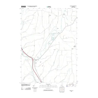
2010 Map of Savona
USGS Topo · Published 2010About this map
The Cohocton River valley defines the western portion of this region, where the village of Savona sits at the junction of local transit routes and watercourses. This landscape is characterized by a series of north-south running valleys and high ground such as Irish Hill and Platt Hill. Moving east, the terrain shifts into a chain of small water bodies including Sanford Lake, Van-Keuren Lake, Round Lake, and Peterson Lake, which are interconnected by the winding path of Mud Creek. These lakes and the surrounding valley provide a distinct contrast to the higher elevations of Oak Hill nearby.
Find a feature on this map
74 named features on this map. Tap any name to fly to it.
Don’t see what you’re looking for? This feature index may not catch every label — zoom into the map to look around manually.
Map Details
Editions of this 2010 Savona Map
This is the sole edition of this map. No revisions or reprints were ever made.
Other maps of this area

1903 · Hammondsport
USGS Topo · 1:62,500

1910 · Bath
USGS Topo · 1:62,500

1914 · Corning
USGS Topo · 1:62,500

1924 · Woodhull
USGS Topo · 1:48,000

1926 · Woodhull
USGS Topo · 1:62,500

1944 · Woodhull
USGS Topo · 1:62,500

1944 · Corning
USGS Topo · 1:62,500

1950 · Elmira
USGS Topo · 1:250,000
1953 · Wayne
USGS Topo · 1:24,000

1953 · Campbell
USGS Topo · 1:24,000