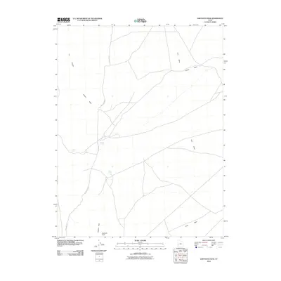
2010 Map of Sawtooth Peak
USGS Topo · Published 2010About this map
Sawtooth Peak rises as a prominent landmark in this desert landscape of western Utah, where seasonal water sources and distinct terrain features defined the movement of early travelers and livestock. The map documents vital water points such as Pots Sum Pa Spring, Mud Spring, and Willow Spring, which were essential for survival in this arid environment. The drainage network is clearly defined by Pine Valley Wash, Jackson Wash, and Turkey Wash, cutting through a topography marked by the striking formations of The Needles and the broad elevation of Elephant Back. This area, primarily characterized by open space and a sparse network of unpaved roads, reflects the enduring character of the Great Basin's high desert country. The inclusion of the Pots Sum-Pa SFG label suggests specific localized nomenclature or land use designations unique to this portion of Beaver County.
Find a feature on this map
11 named features on this map. Tap any name to fly to it.
Don’t see what you’re looking for? This feature index may not catch every label — zoom into the map to look around manually.
Map Details
Editions of this 2010 Sawtooth Peak Map
This is the sole edition of this map. No revisions or reprints were ever made.
Other maps of this area

1953 · Richfield
USGS Topo · 1:250,000

1958 · Richfield
USGS Topo · 1:250,000

1960 · Wah Wah Summit
USGS Topo · 1:62,500

1971 · Pine Grove Reservoir
USGS Topo · 1:24,000

1971 · Mountain Home Pass
USGS Topo · 1:24,000

1971 · Halfway Summit
USGS Topo · 1:24,000

1971 · Sawtooth Peak
USGS Topo · 1:24,000

1971 · Lamerdorf Peak NW
USGS Topo · 1:24,000
1972 · Lopers Spring
USGS Topo · 1:24,000
1972 · Buckhorn Spring
USGS Topo · 1:24,000