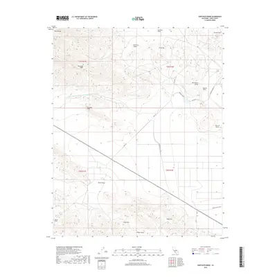
2018 Map of Sawtooth Ridge
USGS Topo · Published 2018About this map
Sawtooth Ridge and the Temblor Range dominate this western Kern County landscape, where the high desert terrain meets the industrial-scale water infrastructure of the Central Valley. The intersection of natural topography and engineering is evident in the path of the Governor Edmund G Brown Coastal-Br California Aqueduct and the California Aqueduct, which cut through the ridges near Point of Rocks. Local landmarks like Hitbrich Grade and Raven Pass reflect the area's history of movement through the hills. Water sources such as Kilmer Spring and Aido Spring stand in contrast to the engineered Berrenda Canal and Berrenda Mesa Canal, illustrating how this arid region in the San Joaquin Valley was transformed for agriculture. The terrain varies from the Shale Hills to the deep White City Canyon, with Rte 46 providing the primary transit corridor through Barrel Valley.
Find a feature on this map
29 named features on this map. Tap any name to fly to it.
Don’t see what you’re looking for? This feature index may not catch every label — zoom into the map to look around manually.
Map Details
Editions of this 2018 Sawtooth Ridge Map
This is the sole edition of this map. No revisions or reprints were ever made.
Other maps of this area

1914 · Lost Hills
USGS Topo · 1:125,000

1914 · Cholame
USGS Topo · 1:125,000

1915 · Cholame
USGS Topo · 1:125,000

1917 · Cholame
USGS Topo · 1:125,000

1930 · Avenal Gap
USGS Topo · 1:31,680

1933 · Avenal Gap
USGS Topo · 1:31,680

1942 · Tent Hills
USGS Topo · 1:24,000

1943 · Packwood
USGS Topo · 1:31,680

1943 · Grant Lake
USGS Topo · 1:31,680
1943 · Tent Hills
USGS Topo · 1:31,680