
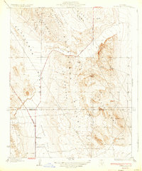
1933 Map of Avenal Gap
USGS Topo · Published 1933About this map
The Kettleman Hills dominate this 1930s landscape where the Central Valley begins its ascent into the interior ranges. This survey captures a specific moment in the development of the California oil fields, highlighting the geological structures of Middle Dome and South Dome which were critical to the era's petroleum exploration. The topographic detail reveals the transition from the flat expanse of the Antelope Plain and Kettleman Plain into the complex drainages of Arroyo Poso and Arroyo Ancho. On the western edge of the hills, the small settlement of Devils Den and the nearby Devils Den Sch represent the sparse human footprint in this arid terrain. Roads connect these outposts to distant hubs like Bakersfield and Coalinga, while the boundary between Kings Co and Kern Co bisects the rugged uplands near Cascajo Hill.
Find a feature on this map
24 named features on this map. Tap any name to fly to it.
Don’t see what you’re looking for? This feature index may not catch every label — zoom into the map to look around manually.
Map Details
Editions of this 1933 Avenal Gap Map
2 editions found
Other maps of this area

1914 · Lost Hills
USGS Topo · 1:125,000

1914 · Cholame
USGS Topo · 1:125,000

1915 · Cholame
USGS Topo · 1:125,000

1917 · Cholame
USGS Topo · 1:125,000

1930 · Avenal Gap
USGS Topo · 1:31,680

1930 · Kettleman Plain
USGS Topo · 1:31,680

1930 · Middle Dome
USGS Topo · 1:31,680

1932 · Dudley Ridge
USGS Topo · 1:31,680

1932 · Antelope Plain
USGS Topo · 1:31,680

1932 · West Camp
USGS Topo · 1:31,680