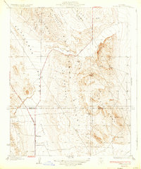
1933 Map of Avenal Gap
USGS Topo · Published 1933About this map
Kettleman Hills dominate this portion of the western San Joaquin Valley, where the topographical complexity of Middle Dome and South Dome meets the flat expanses of the Antelope Plain. In the early 1930s, this landscape was defined by its transition from the steep ridges of Pintojo Ridge and El Caballete to the open ranching or petroleum lands near the Kings and Kern County line. The settlement of Devils Den and the nearby Devils Den Sch represent the sparse human footprint in this arid region, anchored by established travel routes like the Bakersfield Road and Coalinga Road. Seasonal drainage patterns are clearly marked by several arroyos, including Arroyo Toxo and Arroyo Ancho, which cut through the hills toward the Kettleman Plain. This survey captures the area just as the development of the Kettleman Hills oil fields was reshaping the local economy and infrastructure.
Find a feature on this map
29 named features on this map. Tap any name to fly to it.
Don’t see what you’re looking for? This feature index may not catch every label — zoom into the map to look around manually.
Map Details
Editions of this 1933 Avenal Gap Map
2 editions found

Other maps of this area

1914 · Lost Hills
USGS Topo · 1:125,000

1914 · Cholame
USGS Topo · 1:125,000

1915 · Cholame
USGS Topo · 1:125,000

1917 · Cholame
USGS Topo · 1:125,000

1930 · Avenal Gap
USGS Topo · 1:31,680

1930 · Kettleman Plain
USGS Topo · 1:31,680

1930 · Middle Dome
USGS Topo · 1:31,680

1932 · Dudley Ridge
USGS Topo · 1:31,680

1932 · Antelope Plain
USGS Topo · 1:31,680

1932 · West Camp
USGS Topo · 1:31,680