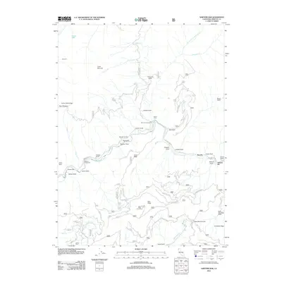
2012 Map of Sawyers Bar
USGS Topo · Published 2012About this map
Sawyers Bar and the neighboring settlement of Bestville anchor this map of the Klamath National Forest area, where the N Fork Salmon River carves through steep drainage systems. This landscape is defined by its gold mining legacy and ranching history, evidenced by family-named landmarks such as Ahlgren Ranch, Burns Ranch, and Godfrey Ranch. The topography is marked by a series of narrow gulches and high ridges, including the prominent Blue Ridge which features the Blue Ridge Lookout Tower.
Find a feature on this map
78 named features on this map. Tap any name to fly to it.
Don’t see what you’re looking for? This feature index may not catch every label — zoom into the map to look around manually.
Map Details
Editions of this 2012 Sawyers Bar Map
This is the sole edition of this map. No revisions or reprints were ever made.
Other maps of this area

1948 · Weed
USGS Topo · 1:250,000

1950 · Weed
USGS Topo · 1:250,000

1955 · Salmon Mtn
USGS Topo · 1:62,500

1955 · Cecilville
USGS Topo · 1:62,500

1955 · Sawyers Bar
USGS Topo · 1:62,500

1955 · Forks of Salmon
USGS Topo · 1:62,500

1958 · Weed
USGS Topo · 1:250,000

1963 · Weed
USGS Topo · 1:250,000
1977 · Yellow Dog Peak
USGS Topo · 1:24,000
1977 · Tanners Peak
USGS Topo · 1:24,000