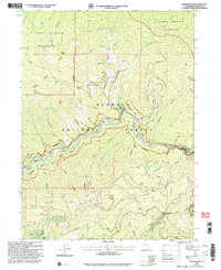
2001 Map of Sawyers Bar
USGS Topo · Published 2004About this map
Sawyers Bar serves as the focal point of this Klamath Mountains survey, situated at the confluence of several steep drainages. The landscape is defined by its deep mining legacy, visible through features like the Dredge Tailings and the Bestville (Site). Further up the surrounding ridges, the Black Bear Mine, Celia Mine, and Hickey Mine mark the intensive extraction efforts that once drove the local economy.
Find a feature on this map
73 named features on this map. Tap any name to fly to it.
Don’t see what you’re looking for? This feature index may not catch every label — zoom into the map to look around manually.
Map Details
Editions of this 2001 Sawyers Bar Map
This is the sole edition of this map. No revisions or reprints were ever made.
Other maps of this area

1948 · Weed
USGS Topo · 1:250,000

1950 · Weed
USGS Topo · 1:250,000

1955 · Salmon Mtn
USGS Topo · 1:62,500

1955 · Cecilville
USGS Topo · 1:62,500

1955 · Sawyers Bar
USGS Topo · 1:62,500

1955 · Forks of Salmon
USGS Topo · 1:62,500

1958 · Weed
USGS Topo · 1:250,000

1963 · Weed
USGS Topo · 1:250,000
1977 · Yellow Dog Peak
USGS Topo · 1:24,000
1977 · Tanners Peak
USGS Topo · 1:24,000