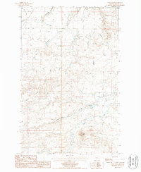
1987 Map of Sayer Butte
USGS Topo · Published 1987About this map
Sayer Butte dominates the southern landscape of this Blaine County quadrangle, rising above a complex network of seasonal drainages and high plateaus. The northern half of the map reveals the era's small-scale industrial footprint, specifically at the Rader Mine where a Mineshaft, Tallings, and Mine Dump are clearly delineated near a high ridge. This localized mining activity, situated between Black Coulee and a northern Landing Strip, suggests a period of targeted resource extraction in an otherwise pastoral setting.
Find a feature on this map
17 named features on this map. Tap any name to fly to it.
Don’t see what you’re looking for? This feature index may not catch every label — zoom into the map to look around manually.
Map Details
Editions of this 1987 Sayer Butte Map
This is the sole edition of this map. No revisions or reprints were ever made.
Other maps of this area

1904 · Yantic
USGS Topo · 1:62,500

1904 · Chinook
USGS Topo · 1:62,500

1912 · Zurich
USGS Topo · 1:125,000

1953 · Havre
USGS Topo · 1:250,000

1956 · Lloyd
USGS Topo · 1:62,500

1956 · Cleveland
USGS Topo · 1:62,500

1957 · Havre
USGS Topo · 1:250,000

1958 · Havre
USGS Topo · 1:250,000
1964 · Lohman SE
USGS Topo · 1:24,000
1964 · Lohman
USGS Topo · 1:24,000