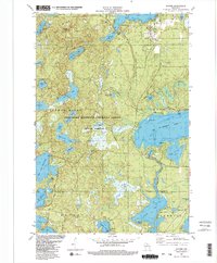
1982 Map of Sayner
USGS Topo · Published 1983About this map
Sayner serves as the primary hub of this glaciated landscape, situated between Plum Lake and Big St Germain Lake. The community is marked by its Post Office and St Marys Ch, reflecting its established role in northern Wisconsin's recreational and timber country. The map captures a transition in transportation, showing the Old Railroad Grade snaking through the forest, a relic of the era when logging lines were the lifelines of the Northwoods.
Find a feature on this map
49 named features on this map. Tap any name to fly to it.
Don’t see what you’re looking for? This feature index may not catch every label — zoom into the map to look around manually.
Map Details
Editions of this 1982 Sayner Map
2 editions found
Other maps of this area

1930 · Robbins
USGS Topo · 1:48,000

1938 · Minocqua
USGS Topo · 1:48,000

1938 · Robbins
USGS Topo · 1:48,000

1939 · Trout Lake
USGS Topo · 1:48,000

1945 · Robbins
USGS Topo · 1:48,000

1946 · Star Lake
USGS Topo · 1:48,000

1946 · Minocqua
USGS Topo · 1:48,000

1946 · Trout Lake
USGS Topo · 1:48,000

1949 · Trout Lake
USGS Topo · 1:48,000

1949 · Minocqua
USGS Topo · 1:48,000