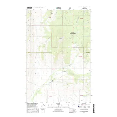
2017 Map of Scab Rock Mountain
USGS Topo · Published 2017About this map
Scab Rock Mountain and the high peaks of the Gallatin National Forest dominate this high-country landscape along the border of Park and Meagher counties. The terrain is defined by a complex drainage system where Sixteenmile Cr flows through the northern reaches while the Shields River winds across the southern flats. A clear transition from the steep elevations of Bear Mtn and Goat Mtn to the lower valley floor is visible, marked by the engineered path of the Horse Camp Ditch and the winding Shields River Rd.
Find a feature on this map
39 named features on this map. Tap any name to fly to it.
Don’t see what you’re looking for? This feature index may not catch every label — zoom into the map to look around manually.
Map Details
Editions of this 2017 Scab Rock Mountain Map
This is the sole edition of this map. No revisions or reprints were ever made.
Other maps of this area

1886 · Little Belt Mts.
USGS Topo · 1:250,000

1894 · Little Belt Mts.
USGS Topo · 1:250,000

1897 · Little Belt Mts.
USGS Topo · 1:250,000

1898 · Little Belt Mts.
USGS Topo · 1:250,000

1902 · Little Belt Mts.
USGS Topo · 1:250,000

1948 · White Sulphur Springs
USGS Topo · 1:250,000

1951 · Hamen
USGS Topo · 1:24,000
1951 · Wolf Hill
USGS Topo · 1:24,000

1951 · Rimrock Divide
USGS Topo · 1:24,000

1958 · White Sulphur Springs
USGS Topo · 1:250,000