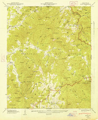
1947 Map of Scaly
USGS Topo · Published 1947About this map
Scaly serves as a central point of settlement in this 1946 field-checked survey of Macon County, where the Nantahala National Forest meets the Blue Ridge divide. The landscape is defined by its ridge-and-valley agriculture and early industry, featuring multiple family-named landmarks such as the Middle Creek Mill and Watkins Mill. These sites, along with the Scaly School and various rural congregations including Drymans Chapel and Hickory Knoll Church, illustrate a deeply rooted mountain community.
Find a feature on this map
150 named features on this map. Tap any name to fly to it.
Don’t see what you’re looking for? This feature index may not catch every label — zoom into the map to look around manually.
Map Details
Editions of this 1947 Scaly Map
2 editions found
Other maps of this area

1886 · Walhalla
USGS Topo · 1:125,000

1891 · Cowee
USGS Topo · 1:125,000

1892 · Walhalla
USGS Topo · 1:125,000

1896 · Walhalla
USGS Topo · 1:125,000

1897 · Cowee
USGS Topo · 1:125,000

1907 · Cowee
USGS Topo · 1:125,000

1935 · Franklin
USGS Topo · 1:24,000

1935 · Prentiss
USGS Topo · 1:24,000

1935 · Dillard
USGS Topo · 1:24,000

1935 · Scaly
USGS Topo · 1:24,000