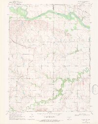
1969 Map of Scandia NW
USGS Topo · Published 1971About this map
The Republican River winds through the northern portion of this landscape, marking the borderlands between Kansas and Nebraska in the late 1960s. The region is defined by an intricate network of irrigation infrastructure and water management, featuring the North Canal, the Miller Canal, and a prominent Pumping Station. This engineered landscape supported the agricultural townships of Jackson, Big Bend, Sinclair, and White Rock.
Find a feature on this map
27 named features on this map. Tap any name to fly to it.
Don’t see what you’re looking for? This feature index may not catch every label — zoom into the map to look around manually.
Map Details
Editions of this 1969 Scandia NW Map
This is the sole edition of this map. No revisions or reprints were ever made.
Other maps of this area

1892 · Concordia
USGS Topo · 1:125,000

1894 · Mankato
USGS Topo · 1:125,000

1898 · Superior
USGS Topo · 1:125,000

1898 · Hebron
USGS Topo · 1:125,000

1955 · Manhattan
USGS Topo · 1:250,000

1955 · Lincoln
USGS Topo · 1:250,000

1955 · Grand Island
USGS Topo · 1:250,000

1955 · Beloit
USGS Topo · 1:250,000

1956 · Manhattan
USGS Topo · 1:250,000

1957 · Manhattan
USGS Topo · 1:250,000