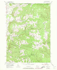
1954 Map of Scandia
USGS Topo · Published 1972About this map
Warren State Hospital anchors the southwestern corner of this Pennsylvania and New York borderland, situated where the terrain begins its ascent toward the heavily timbered tracts of the Allegheny National Forest. The landscape is defined by high ridges like Bone Steel Hill and Heaven Hill, dissected by a dense network of runs including Hatch Run and Akeley Run. The settlement pattern follows a traditional crossroads model typical of the Northern Tier, with small communities and junctions such as Scandia, Clendening Corners, and Lounsbury Corners serving as localized hubs for the surrounding farm and forest lands.
Find a feature on this map
50 named features on this map. Tap any name to fly to it.
Don’t see what you’re looking for? This feature index may not catch every label — zoom into the map to look around manually.
Map Details
Editions of this 1954 Scandia Map
3 editions found
Other maps of this area

1905 · Jamestown
USGS Topo · 1:62,500

1906 · Warren
USGS Topo · 1:62,500

1907 · Warren
USGS Topo · 1:62,500

1908 · Warren
USGS Topo · 1:62,500

1922 · Randolph
USGS Topo · 1:62,500

1923 · Randolph
USGS Topo · 1:62,500

1936 · Kinzua
USGS Topo · 1:48,000

1941 · Kinzua
USGS Topo · 1:62,500

1942 · Jamestown
USGS Topo · 1:62,500

1943 · Randolph
USGS Topo · 1:62,500