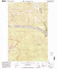
1997 Map of Scenery Mountain
USGS Topo · Published 2000About this map
The Kootenai River carves a dramatic path through the heart of this high-elevation landscape, defining the corridor between the Three Rivers District and the Libby District. This 1997 revision shows the intersection of heavy timber management and protected backcountry, where the Kootenai National Forest transitions into the primitive Cabinet Mountains Wilderness. High peaks such as Scenery Mountain and Gramsbaur Mountain overlook a complex drainage system including Cedar Creek and Williams Creek.
Find a feature on this map
30 named features on this map. Tap any name to fly to it.
Don’t see what you’re looking for? This feature index may not catch every label — zoom into the map to look around manually.
Map Details
Editions of this 1997 Scenery Mountain Map
This is the sole edition of this map. No revisions or reprints were ever made.
Other maps of this area

1920 · Libby
USGS Topo · 1:125,000

1930 · Libby
USGS Topo · 1:125,000

1932 · Libby
USGS Topo · 1:125,000

1957 · Kalispell
USGS Topo · 1:250,000

1960 · Kalispell
USGS Topo · 1:250,000

1961 · Kalispell
USGS Topo · 1:250,000

1963 · Scenery Mountain
USGS Topo · 1:24,000

1963 · Turner Mountain
USGS Topo · 1:24,000

1963 · Pulpit Mountain
USGS Topo · 1:24,000

1963 · Treasure Mountain
USGS Topo · 1:24,000