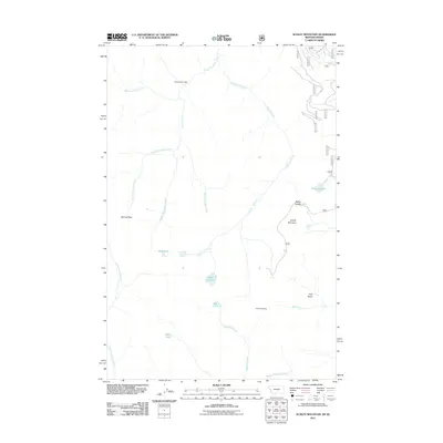
2011 Map of Schley Mountain
USGS Topo · Published 2011About this map
Admiral Peak and Schley Mountain define the high ridgelines of this section of the Bitterroot Range along the Montana-Idaho border. The landscape is dominated by complex drainage systems, where the headwaters of Indian Creek and Cedar Log Creek carve deep valleys through the terrain. Evidence of high-altitude habitation and industry appears at Indian Creek Lodge in the north and the Snowshoe Mine further south near Irish Creek. The geography is dotted with several alpine water bodies, including the Cedar Log Lakes, Kelly Lake, and Surveyor Lake, which are tucked into glacial cirques like the Irish Basin. This 2011 survey captures the area's transition into a modern recreational and conservation landscape, while still preserving the nomenclature of its early mining and exploration history.
Find a feature on this map
24 named features on this map. Tap any name to fly to it.
Don’t see what you’re looking for? This feature index may not catch every label — zoom into the map to look around manually.
Map Details
Editions of this 2011 Schley Mountain Map
This is the sole edition of this map. No revisions or reprints were ever made.
Other maps of this area

1911 · Lolo
USGS Topo · 1:250,000

1913 · Lolo
USGS Topo · 1:250,000

1956 · Hamilton
USGS Topo · 1:250,000

1959 · Hamilton
USGS Topo · 1:250,000

1960 · Hamilton
USGS Topo · 1:250,000

1960 · Straight Peak
USGS Topo · 1:62,500

1964 · Hamilton
USGS Topo · 1:250,000
1964 · Williams Peak
USGS Topo · 1:24,000
1964 · White Mountain
USGS Topo · 1:24,000
1964 · Granite Pass
USGS Topo · 1:24,000