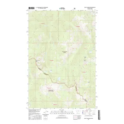
2017 Map of Schley Mountain
USGS Topo · Published 2017About this map
Schley Mountain and Admiral Peak anchor this high-elevation segment of the Bitterroot Range, where the continental divide marks the state boundary between Montana and Idaho. The terrain is defined by a complex drainage system within the Lolo National Forest and Clearwater National Forest, including the headwaters of W Fork Fish Cr and N Fork Kelly Cr. A series of subalpine lakes, such as Surveyor Lake, Kelly Lake, and the Cedar Log Lakes, are tucked into glacial cirques below the ridges. This 2017 survey illustrates the remote wilderness character of the region, showing a landscape shaped by water and rock rather than human settlement, with the boundary between Mineral County and Clearwater County tracing the high crests of the mountains.
Find a feature on this map
46 named features on this map. Tap any name to fly to it.
Don’t see what you’re looking for? This feature index may not catch every label — zoom into the map to look around manually.
Map Details
Editions of this 2017 Schley Mountain Map
This is the sole edition of this map. No revisions or reprints were ever made.
Other maps of this area

1911 · Lolo
USGS Topo · 1:250,000

1913 · Lolo
USGS Topo · 1:250,000

1956 · Hamilton
USGS Topo · 1:250,000

1959 · Hamilton
USGS Topo · 1:250,000

1960 · Hamilton
USGS Topo · 1:250,000

1960 · Straight Peak
USGS Topo · 1:62,500

1964 · Hamilton
USGS Topo · 1:250,000
1964 · Williams Peak
USGS Topo · 1:24,000
1964 · White Mountain
USGS Topo · 1:24,000
1964 · Granite Pass
USGS Topo · 1:24,000