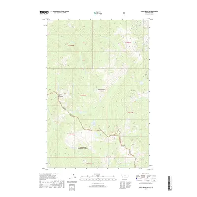
2020 Map of Schley Mountain
USGS Topo · Published 2020About this map
The Bitterroot Range forms a formidable natural boundary along the Montana-Idaho state line, where the high-altitude wilderness of Lolo National Forest meets the Clearwater National Forest. This remote landscape is defined by its dramatic crests, including Schley Mtn and Admiral Peak, which overlook a complex network of high mountain basins and glacial waters. Below the steep pass of Schley Saddle, numerous small bodies of water like Cedar Log Lakes, Kelly Lake, and Kid Lake collect in the high cirques. The drainage patterns are intricate, with various branches of Indian Cr and Cedar Log Cr carving deep into the terrain. This map documents a largely roadless interior, marked only by isolated forest service routes like 18001, serving as a critical record of the undisturbed topography between Mineral County, Montana, and Clearwater County, Idaho.
Find a feature on this map
36 named features on this map. Tap any name to fly to it.
Don’t see what you’re looking for? This feature index may not catch every label — zoom into the map to look around manually.
Map Details
Editions of this 2020 Schley Mountain Map
This is the sole edition of this map. No revisions or reprints were ever made.
Other maps of this area

1911 · Lolo
USGS Topo · 1:250,000

1913 · Lolo
USGS Topo · 1:250,000

1956 · Hamilton
USGS Topo · 1:250,000

1959 · Hamilton
USGS Topo · 1:250,000

1960 · Hamilton
USGS Topo · 1:250,000

1960 · Straight Peak
USGS Topo · 1:62,500

1964 · Hamilton
USGS Topo · 1:250,000
1964 · Williams Peak
USGS Topo · 1:24,000
1964 · White Mountain
USGS Topo · 1:24,000
1964 · Granite Pass
USGS Topo · 1:24,000