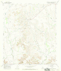
1967 Map of Schneeman Draw SW
USGS Topo · Published 1970About this map
Todd Deep Oil Field anchors this mid-century survey of the West Texas landscape, illustrating the industrial footprint of the petroleum industry during the late 1960s. The map reveals a dense network of energy infrastructure, including an active refinery and multiple gas wells, connected by a complex system of pipelines that traverse the arid terrain. Amidst this industrial activity, historical land use is marked by scattered outposts like Fields Ranch and Bean Ranch, which signify the enduring presence of ranching in Crockett County.
Find a feature on this map
18 named features on this map. Tap any name to fly to it.
Don’t see what you’re looking for? This feature index may not catch every label — zoom into the map to look around manually.
Map Details
Editions of this 1967 Schneeman Draw SW Map
This is the sole edition of this map. No revisions or reprints were ever made.
Other maps of this area

1929 · Sheffield
USGS Topo · 1:125,000

1954 · Sonora
USGS Topo · 1:250,000

1958 · Sonora
USGS Topo · 1:250,000

1967 · Owens Creek SE
USGS Topo · 1:24,000

1967 · Owens Creek NE
USGS Topo · 1:24,000

1967 · Schneeman Draw NW
USGS Topo · 1:24,000
1967 · Schneeman Draw NE
USGS Topo · 1:24,000

1967 · Pikes Peak
USGS Topo · 1:24,000

1967 · Bachelor Hill
USGS Topo · 1:24,000
1967 · Schneeman Draw SE
USGS Topo · 1:24,000