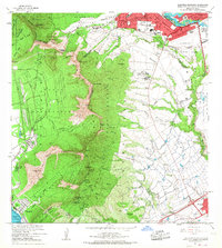
1967 Map of Schofield Barracks
USGS Topo · Published 1968About this map
Schofield Barracks Military Reservation and the sprawling facilities of Wheeler Air Force Base anchor the central plateau of Oahu in this 1960s survey. The landscape is defined by the sharp verticality of the Waianae Range, where landmarks like Puu Hapapa and Puu Kanehoa separate the military and agricultural lowlands from the coastal reaches of Nanakuli. Local life is visible in the residential pockets of Wahiawa and the specialized settlement at Kunia Camp, while the Waiahole Ditch system illustrates the island's complex water management for mid-century agriculture. From the Kolekole Pass to the industrial quarry near the Pacific, the map documents a period of significant military presence and infrastructure development, including the early construction phases of the h1 highway and the recreational grounds of the Hawaii Country Club.
Find a feature on this map
65 named features on this map. Tap any name to fly to it.
Don’t see what you’re looking for? This feature index may not catch every label — zoom into the map to look around manually.
Map Details
Editions of this 1967 Schofield Barracks Map
This is the sole edition of this map. No revisions or reprints were ever made.
Other maps of this area

1953 · Haleiwa
USGS Topo · 1:24,000

1953 · Schofield Barracks
USGS Topo · 1:24,000

1953 · Ewa
USGS Topo · 1:24,000

1953 · Puuloa
USGS Topo · 1:24,000

1953 · Hauula
USGS Topo · 1:24,000

1954 · Oahu
USGS Topo · 1:250,000

1954 · Waianae
USGS Topo · 1:24,000

1954 · Kaena
USGS Topo · 1:24,000

1954 · Waipahu
USGS Topo · 1:24,000

1959 · Waipahu
USGS Topo · 1:24,000