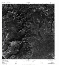
1977 Map of Schofield Barracks
USGS Topo · Published 1984About this map
Schofield Barracks and the surrounding O'ahu landscape are captured here in high-contrast detail, revealing the sharp divide between military installations and the steep ridges of the Wai'anae Range. The orthophoto imagery, derived from 1970s aerial photography, provides a rare look at the footprint of the Lualualei Naval Ammunition Depot (Niulii Res) tucked against the mountains. To the southwest, the coastal settlement of Nanakuli sits near the shore of the Pacific Ocean, showing the extent of residential development before later modernization. The drainage of Waikele Stream cuts through the central plateau, illustrating how the natural topography dictated the placement of agricultural fields and military infrastructure in this critical central corridor of the island.
Find a feature on this map
6 named features on this map. Tap any name to fly to it.
Don’t see what you’re looking for? This feature index may not catch every label — zoom into the map to look around manually.
Map Details
Editions of this 1977 Schofield Barracks Map
This is the sole edition of this map. No revisions or reprints were ever made.
Other maps of this area

1953 · Haleiwa
USGS Topo · 1:24,000

1953 · Schofield Barracks
USGS Topo · 1:24,000

1953 · Ewa
USGS Topo · 1:24,000

1953 · Puuloa
USGS Topo · 1:24,000

1953 · Hauula
USGS Topo · 1:24,000

1954 · Oahu
USGS Topo · 1:250,000

1954 · Waianae
USGS Topo · 1:24,000

1954 · Kaena
USGS Topo · 1:24,000

1954 · Waipahu
USGS Topo · 1:24,000

1959 · Waipahu
USGS Topo · 1:24,000