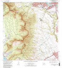
1983 Map of Schofield Barracks
USGS Topo · Published 1983About this map
The Waianae Range forms a dramatic central spine across this mid-century landscape, separating the military and agricultural plateaus from the leeward coast. At the northern heights, Schofield Barracks Military Reservation and Wheeler Air Force Base anchor a massive defense footprint that dominated the geography of central Oahu by the 1980s. The town of Wahiawa is shown bordered by the Wahiawa Reservoir and the Wahiawa State Freshwater Park, while to the south, the expansion of Waipahu and Kunia illustrates the residential growth encroaching on former pineapple and sugarcane lands.
Find a feature on this map
68 named features on this map. Tap any name to fly to it.
Don’t see what you’re looking for? This feature index may not catch every label — zoom into the map to look around manually.
Map Details
Editions of this 1983 Schofield Barracks Map
This is the sole edition of this map. No revisions or reprints were ever made.
Other maps of this area

1953 · Haleiwa
USGS Topo · 1:24,000

1953 · Schofield Barracks
USGS Topo · 1:24,000

1953 · Ewa
USGS Topo · 1:24,000

1953 · Puuloa
USGS Topo · 1:24,000

1953 · Hauula
USGS Topo · 1:24,000

1954 · Oahu
USGS Topo · 1:250,000

1954 · Waianae
USGS Topo · 1:24,000

1954 · Kaena
USGS Topo · 1:24,000

1954 · Waipahu
USGS Topo · 1:24,000

1959 · Waipahu
USGS Topo · 1:24,000