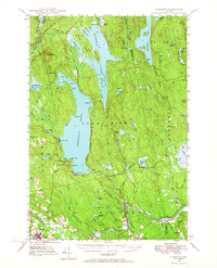
1947 Map of Schoodic
USGS Topo · Published 1967About this map
Schoodic Lake and its surrounding Maine timberlands define this 1940s landscape, where the Canadian Pacific and Bangor and Aroostook railroads intersect near the settlement of Lake View. The map captures a transition in North Woods transportation, showing the heavy reliance on rail to navigate the dense network of water bodies like Seboeis Lake and Endless Lake. Local life is anchored by small settlements such as Medford and Milo, with isolated outposts like Knights Landing and Adams dotting the shorelines.
Find a feature on this map
72 named features on this map. Tap any name to fly to it.
Don’t see what you’re looking for? This feature index may not catch every label — zoom into the map to look around manually.
Map Details
Editions of this 1947 Schoodic Map
Other maps of this area

1917 · Passadumkeag
USGS Topo · 1:62,500

1932 · Dover-Foxcroft
USGS Topo · 1:48,000

1933 · Boyd Lake
USGS Topo · 1:62,500

1935 · Dover-Foxcroft
USGS Topo · 1:62,500

1940 · Sebec
USGS Topo · 1:48,000

1942 · Lincoln
USGS Topo · 1:62,500

1943 · Sebec
USGS Topo · 1:62,500

1947 · Schoodic
USGS Topo · 1:62,500

1949 · Schoodic
USGS Topo · 1:62,500

1951 · Boyd Lake
USGS Topo · 1:50,000