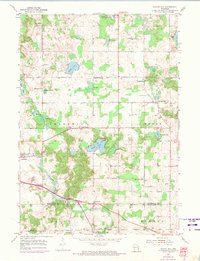
1954 Map of School Hill
USGS Topo · Published 1974About this map
Glacial geology and agricultural settlement define this part of the Wisconsin lakeshore region, where the Sheboygan River winds through the townships of Schleswig and Rhine. The landscape is characterized by numerous small bodies of water, including the prominent Cedar Lake and Wilke Lake, alongside many smaller basins like Shoe Lake and Horseshoe Lake. Small crossroads communities and rural institutions serve as the primary landmarks, notably the Salvatorian Seminary and various local parishes like Lax Chapel and Bethlehem Ch.
Find a feature on this map
40 named features on this map. Tap any name to fly to it.
Don’t see what you’re looking for? This feature index may not catch every label — zoom into the map to look around manually.
Map Details
Editions of this 1954 School Hill Map
2 editions found
Other maps of this area

1954 · School Hill
USGS Topo · 1:24,000

1954 · St. Wendel
USGS Topo · 1:24,000

1954 · Howards Grove
USGS Topo · 1:62,500

1954 · Howards Grove
USGS Topo · 1:24,000

1954 · Chilton
USGS Topo · 1:62,500

1954 · Reedsville
USGS Topo · 1:62,500

1954 · Franklin
USGS Topo · 1:24,000

1954 · Kiel
USGS Topo · 1:62,500

1954 · Milwaukee
USGS Topo · 1:250,000

1954 · Manitowoc
USGS Topo · 1:250,000