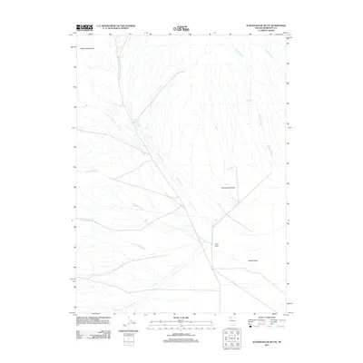
2011 Map of Schoolhouse Butte
USGS Topo · Published 2011About this map
Jackson Mountains dominate the western edge of this landscape, where the high terrain gives way to the expansive floor of Desert Valley. The hydrological network here is defined by numerous intermittent drainages that descend from the peaks, including Clover Creek, Louise Creek, and Trout Creek, which cross the arid flats. This high-desert environment shows very little modern development, centered primarily around the Trout Creek Ranch located near the base of the foothills. Distinctive landmarks like Schoolhouse Butte serve as navigational anchors in a region where water sources like Willows Spring were essential for early ranching operations. The mapping of Big Cedar Creek and Little Cedar Creek illustrates the complex drainage patterns of the Great Basin as they flow toward the central valley basin.
Find a feature on this map
15 named features on this map. Tap any name to fly to it.
Don’t see what you’re looking for? This feature index may not catch every label — zoom into the map to look around manually.
Map Details
Editions of this 2011 Schoolhouse Butte Map
This is the sole edition of this map. No revisions or reprints were ever made.
Other maps of this area

1886 · Disaster
USGS Topo · 1:250,000

1893 · Disaster
USGS Topo · 1:250,000

1954 · Vya
USGS Topo · 1:250,000

1958 · Vya
USGS Topo · 1:250,000

1961 · Bottle Creek
USGS Topo · 1:62,500

1962 · Vya
USGS Topo · 1:250,000

1966 · Donna Schee Peak
USGS Topo · 1:62,500

1966 · King Lear Peak
USGS Topo · 1:62,500

1972 · Hobo Canyon
USGS Topo · 1:24,000
1985 · Jackson Mts
USGS Topo · 1:100,000