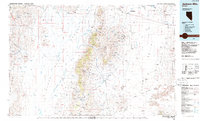
1985 Map of Jackson Mts
USGS Topo · Published 1985About this map
The Jackson Mountains and the arid expanse of the Black Rock Desert dominate this mid-1980s topographical study of northern Nevada. This landscape is defined by its isolation and the critical importance of water, evidenced by a network of named wells such as Mormon Dan Well, Franklin Well, and Austin Well scattered across the sagebrush basins. Along the eastern front of the range, a concentrated mining history is revealed through sites like the Nabuhl Mine, Red Ore Mine, and the Iron King Mine, illustrating the mineral extraction that has long shaped Humboldt County's economy.
Find a feature on this map
110 named features on this map. Tap any name to fly to it.
Don’t see what you’re looking for? This feature index may not catch every label — zoom into the map to look around manually.
Map Details
Editions of this 1985 Jackson Mts Map
2 editions found
Other maps of this area

1882 · Paradise
USGS Topo · 1:250,000

1886 · Disaster
USGS Topo · 1:250,000

1886 · Granite Range
USGS Topo · 1:250,000

1889 · Long Valley
USGS Topo · 1:250,000

1893 · Paradise
USGS Topo · 1:250,000

1893 · Disaster
USGS Topo · 1:250,000

1894 · Granite Range
USGS Topo · 1:250,000

1931 · Lovelock
USGS Topo · 1:250,000

1932 · Sonoma Range
USGS Topo · 1:250,000

1935 · Lovelock
USGS Topo · 1:250,000