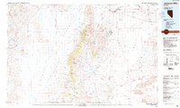
1985 Map of Jackson Mts
USGS Topo · Published 1985About this map
The Jackson Mountains dominate the center of this high-desert Nevada landscape, rising sharply between the arid expanse of the Black Rock Desert and Desert Valley. By the mid-1980s, the region remained a patchwork of mining operations and remote water improvements necessary for ranching. Activity is concentrated around several distinct peaks, including Parrot Peak, King Lear Peak, and Navajo Peak. The presence of numerous extraction sites such as the Red Ore Mine, White Peaks Mine, and Pickhandle Mine illustrates the persistent mineral interest throughout the Slumbering Hills and the central range. On the northern edge, a portion of the Fort Mc Dermitt Indian Reservation is visible along the Quinn River. Water management for livestock is evident through a network of family-named features like Bill DeLong Well and Lee Windmill, while the flat valley floors are marked by features such as the Sod House and the Hidden Playa.
Find a feature on this map
104 named features on this map. Tap any name to fly to it.
Don’t see what you’re looking for? This feature index may not catch every label — zoom into the map to look around manually.
Map Details
Editions of this 1985 Jackson Mts Map
2 editions found
Other maps of this area

1882 · Paradise
USGS Topo · 1:250,000

1886 · Disaster
USGS Topo · 1:250,000

1886 · Granite Range
USGS Topo · 1:250,000

1889 · Long Valley
USGS Topo · 1:250,000

1893 · Paradise
USGS Topo · 1:250,000

1893 · Disaster
USGS Topo · 1:250,000

1894 · Granite Range
USGS Topo · 1:250,000

1931 · Lovelock
USGS Topo · 1:250,000

1932 · Sonoma Range
USGS Topo · 1:250,000

1935 · Lovelock
USGS Topo · 1:250,000