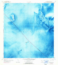
1972 Map of Schooner Bank
USGS Topo · Published 1990About this map
Florida Bay's intricate marine topography is the focus of this 1970s orthophotomap, revealing the shallow banks and basins that define this portion of Everglades National Park. Unlike standard topographic sheets, this edition uses aerial photography taken in 1971 to visualize the submerged landscape, highlighting the serpentine channels of Ninemile Bank and the broad expanse of Rabbit Key Basin. The map tracks the Indefinite Boundary crossing through open water, marked by navigational aids like the Light near Schooner Bank. These shoals, including Sprigger Bank and Oxfoot Bank, illustrate the complex estuarine environment where the Florida peninsula meets the sea, providing a rare look at the underwater geography of the Keys region before later environmental shifts.
Find a feature on this map
15 named features on this map. Tap any name to fly to it.
Don’t see what you’re looking for? This feature index may not catch every label — zoom into the map to look around manually.
Map Details
Editions of this 1972 Schooner Bank Map
2 editions found
Other maps of this area

1956 · Miami
USGS Topo · 1:250,000

1958 · Miami
USGS Topo · 1:250,000

1971 · Grassy Key
USGS Topo · 1:24,000

1971 · Long Key
USGS Topo · 1:24,000

1972 · Bamboo Key
USGS Topo · 1:24,000

1972 · Schooner Bank
USGS Topo · 1:24,000

1972 · East Bahia Honda Key NE
USGS Topo · 1:24,000

1972 · Pelican Keys
USGS Topo · 1:24,000

1972 · Sandy Key
USGS Topo · 1:24,000

1972 · Buchanan Keys
USGS Topo · 1:24,000