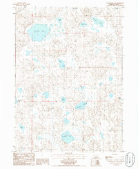
1986 Map of Schoonover Lake
USGS Topo · Published 1986About this map
The rolling sand hills of Garden County, Nebraska, define the landscape of this mid-1980s survey. A dense concentration of seasonal and permanent water bodies, collectively known as the Chain of Lakes, punctuates the sandy terrain. Large basins like Schoonover Lake and Sandbeach Lake dominate the hydrology of the region, providing vital water sources in an otherwise arid environment.
Find a feature on this map
18 named features on this map. Tap any name to fly to it.
Don’t see what you’re looking for? This feature index may not catch every label — zoom into the map to look around manually.
Map Details
Editions of this 1986 Schoonover Lake Map
This is the sole edition of this map. No revisions or reprints were ever made.
Other maps of this area

1896 · Browns Creek
USGS Topo · 1:125,000

1899 · Browns Creek
USGS Topo · 1:125,000

1948 · Antioch
USGS Topo · 1:62,500

1948 · Lakeside
USGS Topo · 1:62,500

1949 · Mumper
USGS Topo · 1:62,500

1949 · Antioch
USGS Topo · 1:62,500

1950 · Storm Lake
USGS Topo · 1:62,500

1950 · Lakeside
USGS Topo · 1:62,500

1954 · Scottsbluff
USGS Topo · 1:250,000

1955 · Alliance
USGS Topo · 1:250,000