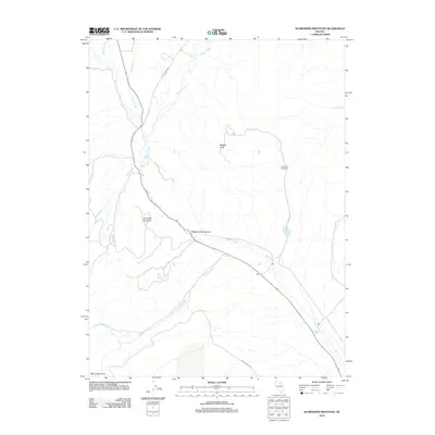
2012 Map of Schroeder Mountain
USGS Topo · Published 2012About this map
Maggie Creek winds through the center of this high desert terrain, carving the notable Maggie Creek Canyon as it flows southeast toward the Humboldt River basin. The landscape is defined by significant elevations, including Schroeder Mountain and Maggie Peak, while Marys Mountain anchors the southwestern corner. This area in Elko County shows a network of remote access routes such as Maggie Creek Rd and James Creek Rd, which follow the natural contours of the drainage basins. A lone landmark of human activity, Hadleys Windmill, stands near the eastern edge, indicating the long-standing reliance on groundwater for ranching in this arid environment. Several smaller tributaries, including Simon Creek, Lynn Creek, and Soap Creek, feed into the primary waterway, illustrating the complex hydrologic system of the Nevada interior during the early 21st century.
Find a feature on this map
12 named features on this map. Tap any name to fly to it.
Don’t see what you’re looking for? This feature index may not catch every label — zoom into the map to look around manually.
Map Details
Editions of this 2012 Schroeder Mountain Map
This is the sole edition of this map. No revisions or reprints were ever made.
Other maps of this area

1952 · Carlin
USGS Topo · 1:62,500

1955 · Winnemucca
USGS Topo · 1:250,000

1957 · Beowawe
USGS Topo · 1:62,500

1958 · Winnemucca
USGS Topo · 1:250,000

1958 · Huntsman Ranch
USGS Topo · 1:24,000
1958 · Swales Mountain
USGS Topo · 1:24,000

1962 · Winnemucca
USGS Topo · 1:250,000

1968 · Rodeo Creek NE
USGS Topo · 1:24,000

1968 · Welches Canyon
USGS Topo · 1:24,000

1968 · Swales Mountain NW
USGS Topo · 1:24,000