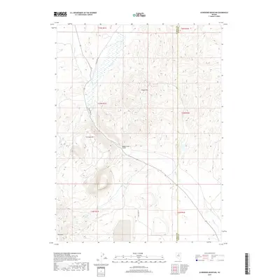
2018 Map of Schroeder Mountain
USGS Topo · Published 2018About this map
Schroeder Mtn and Maggie Peak dominate this high-desert landscape in Elko and Eureka counties. The terrain is defined by the sharp descent into Maggie Creek Canyon, where the waters of Maggie Creek flow south alongside Maggie Creek Rd. To the west, the slopes of Marys Mtn rise above a network of drainages including Soap Cr and James Cr, illustrating the complex watershed system of the region. This 2018 survey reveals a sparse human footprint centered on these primary access roads and the surveyor's grid, including James Creek Rd in the southern portion. The placement of the Eureka Co Elko Co boundary line running north-to-south provides a clear reference for the division of land management and local jurisdiction across this mountainous Nevada interior.
Find a feature on this map
19 named features on this map. Tap any name to fly to it.
Don’t see what you’re looking for? This feature index may not catch every label — zoom into the map to look around manually.
Map Details
Editions of this 2018 Schroeder Mountain Map
This is the sole edition of this map. No revisions or reprints were ever made.
Other maps of this area

1952 · Carlin
USGS Topo · 1:62,500

1955 · Winnemucca
USGS Topo · 1:250,000

1957 · Beowawe
USGS Topo · 1:62,500

1958 · Winnemucca
USGS Topo · 1:250,000

1958 · Huntsman Ranch
USGS Topo · 1:24,000
1958 · Swales Mountain
USGS Topo · 1:24,000

1962 · Winnemucca
USGS Topo · 1:250,000

1968 · Rodeo Creek NE
USGS Topo · 1:24,000

1968 · Welches Canyon
USGS Topo · 1:24,000

1968 · Swales Mountain NW
USGS Topo · 1:24,000