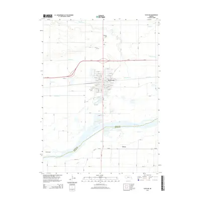
2014 Map of Schuyler
USGS Topo · Published 2014About this map
Schuyler serves as the focal point of this region, situated just north of the Platte River where the landscape is defined by a complex network of agricultural drainage and natural waterways. The map illustrates an intricate system of water management including the Nieman Ditch, Shonka Ditch, and Barnholdt Ditch, which redirect water across the flat valley floor toward Shell Creek and Lost Creek. This engineering reflects the area's intensive agricultural character, while landmarks like Brewery Hill provide rare elevation in the otherwise level terrain. To the south, the village of Edholm sits near the crossing of the Colfax Co Butler Co line, amidst the shifting channels and sandbars of the river. Local history is anchored by sites such as Schuyler Cem and Holy Cross Cem, while Schuyler City Lake offers a distinct recreational feature within the city limits.
Find a feature on this map
80 named features on this map. Tap any name to fly to it.
Don’t see what you’re looking for? This feature index may not catch every label — zoom into the map to look around manually.
Map Details
Editions of this 2014 Schuyler Map
This is the sole edition of this map. No revisions or reprints were ever made.
Other maps of this area

1899 · Wahoo
USGS Topo · 1:125,000

1899 · David City
USGS Topo · 1:125,000

1955 · Fremont
USGS Topo · 1:250,000

1957 · Fremont
USGS Topo · 1:250,000

1958 · Fremont
USGS Topo · 1:250,000

1966 · Clarkson SW
USGS Topo · 1:24,000

1966 · Dodge SW
USGS Topo · 1:24,000
1966 · Clarkson SE
USGS Topo · 1:24,000

1968 · Bruno
USGS Topo · 1:24,000
1968 · David City West
USGS Topo · 1:24,000