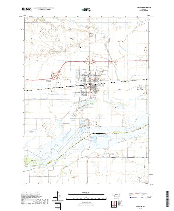
2021 Map of Schuyler
USGS Topo · Published 2021About this map
The Platte River corridor defines the southern landscape of this 2021 survey, where the river's wide, braided channels pass Tomek Island and the small settlement of Edholm. To the north, the city of Schuyler serves as a regional hub, anchored by the Colfax County Courthouse and an extensive grid of numbered streets. The local geography is heavily influenced by a network of drainage and irrigation infrastructure, including the Nieman Ditch, Shonka Ditch, and Hughes Payzant Ditch, which manage the flow around Shell Creek. Genealogists and local historians can locate the Schuyler Cem and Holy Cross Cem on the town's periphery, while the Union Pacific railroad tracks bisect the community, marking the enduring importance of this transit artery through the Nebraska plains.
Find a feature on this map
81 named features on this map. Tap any name to fly to it.
Don’t see what you’re looking for? This feature index may not catch every label — zoom into the map to look around manually.
Map Details
Editions of this 2021 Schuyler Map
This is the sole edition of this map. No revisions or reprints were ever made.
Other maps of this area

1899 · Wahoo
USGS Topo · 1:125,000

1899 · David City
USGS Topo · 1:125,000

1955 · Fremont
USGS Topo · 1:250,000

1957 · Fremont
USGS Topo · 1:250,000

1958 · Fremont
USGS Topo · 1:250,000

1966 · Clarkson SW
USGS Topo · 1:24,000

1966 · Dodge SW
USGS Topo · 1:24,000
1966 · Clarkson SE
USGS Topo · 1:24,000

1968 · Bruno
USGS Topo · 1:24,000
1968 · David City West
USGS Topo · 1:24,000