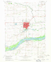
1968 Map of Schuyler
USGS Topo · Published 1971About this map
The Platte River defines the southern reach of this landscape, its braided channels and sandbars flowing past Tomek Island near the boundary of Colfax and Butler counties. North of the river, the settlement of Schuyler serves as a significant regional hub, where the Union Pacific railroad corridor meets a dense grid of town streets. This 1960s survey captures a community deeply rooted in its agricultural and transport infrastructure, evidenced by the numerous irrigation ditches like Hughes Ditch and Payzant Ditch that crisscross the surrounding plains.
Find a feature on this map
46 named features on this map. Tap any name to fly to it.
Don’t see what you’re looking for? This feature index may not catch every label — zoom into the map to look around manually.
Map Details
Editions of this 1968 Schuyler Map
This is the sole edition of this map. No revisions or reprints were ever made.
Other maps of this area

1899 · Wahoo
USGS Topo · 1:125,000

1899 · David City
USGS Topo · 1:125,000

1955 · Fremont
USGS Topo · 1:250,000

1957 · Fremont
USGS Topo · 1:250,000

1958 · Fremont
USGS Topo · 1:250,000

1966 · Clarkson SW
USGS Topo · 1:24,000

1966 · Dodge SW
USGS Topo · 1:24,000
1966 · Clarkson SE
USGS Topo · 1:24,000

1968 · Bruno
USGS Topo · 1:24,000
1968 · David City West
USGS Topo · 1:24,000