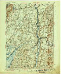
1940 Map of Schuylerville
USGS Topo · Published 1940About this map
Saratoga Battlefield and the Saratoga Battle Monument anchor the southern reach of this landscape, marking the historic grounds where the Hudson valley’s military and agricultural history converge. The Hudson River serves as the primary artery, accompanied by the evolving infrastructure of the Barge Canal and traces of the Champlain Canal (Abandoned). Industrial centers like Victory Mills and Greenwich sit near the confluence of Fish Creek and the Batten Kill, while the western edge is defined by the shoreline of Saratoga Lake and the rising slopes of Mount McGregor. Numerous crossroads like Gansevoort, Quaker Springs, and Bacon Hill illustrate the dense network of rural school districts and family-named corners typical of the pre-war era. This 1940 edition reflects a period when the river-and-rail economy, supported by the Delaware and Hudson and Boston and Maine railroads, sustained these upstate communities.
Find a feature on this map
106 named features on this map. Tap any name to fly to it.
Don’t see what you’re looking for? This feature index may not catch every label — zoom into the map to look around manually.
Map Details
Editions of this 1940 Schuylerville Map
3 editions found
Other maps of this area

1893 · Cohoes
USGS Topo · 1:62,500

1893 · Schenectady
USGS Topo · 1:62,500

1893 · Fort Ann
USGS Topo · 1:62,500

1895 · Cohoes
USGS Topo · 1:62,500

1895 · Cambridge
USGS Topo · 1:62,500

1895 · Fort Ann
USGS Topo · 1:62,500

1895 · Schenectady
USGS Topo · 1:62,500

1895 · Glens Falls
USGS Topo · 1:62,500

1897 · Glens Falls
USGS Topo · 1:62,500

1897 · Hoosick
USGS Topo · 1:62,500