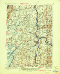
1940 Map of Schuylerville
USGS Topo · Published 1945About this map
The Saratoga Battlefield and the towering Saratoga Battle Monument anchor the southern portion of this region, marking the site of a pivotal American Revolution turning point. By the mid-20th century, the landscape shows a dense network of industrial and transport history where the Hudson River meets the Barge Canal and the Champlain Canal. Manufacturing hubs like Victory Mills and Thomson sit alongside the winding Batten Kill, while the Delaware and Hudson railroad facilitates movement through the valley. Beyond the river towns of Schuylerville and Greenwich, the map reveals a rural interior dotted with numbered schoolhouses and small family-named corners such as Dimmick Corners and Hickeys Corners. The presence of the Glen Alden Trout Hatchery and Lake George Fish Hatchery near Mount McGregor highlights the importance of managed natural resources in the Adirondack foothills.
Find a feature on this map
119 named features on this map. Tap any name to fly to it.
Don’t see what you’re looking for? This feature index may not catch every label — zoom into the map to look around manually.
Map Details
Editions of this 1940 Schuylerville Map
3 editions found
Other maps of this area

1893 · Cohoes
USGS Topo · 1:62,500

1893 · Schenectady
USGS Topo · 1:62,500

1893 · Fort Ann
USGS Topo · 1:62,500

1895 · Cohoes
USGS Topo · 1:62,500

1895 · Cambridge
USGS Topo · 1:62,500

1895 · Fort Ann
USGS Topo · 1:62,500

1895 · Schenectady
USGS Topo · 1:62,500

1895 · Glens Falls
USGS Topo · 1:62,500

1897 · Glens Falls
USGS Topo · 1:62,500

1897 · Hoosick
USGS Topo · 1:62,500